
Communication Builds Our Community
Communication Builds Our Community
Sorted by date Results 1 - 25 of 132
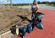
Working in 95-degree heat on a Tuesday afternoon, one Lake Wales woman demonstrated her commitment to making the world "a bit better or more beautiful." La Casa resident Carol Sundheim was spotted working alone with hand tools to clean up the prominent roundabout at the intersection of Scenic Highway and Hunt Brothers Road at the southern end of the city. Asked why she had undertaken the project, she had a simple and civic-minded response: "It's Lake Wales! I mean, come on! I...

After a soggy end to May, Floridians are looking forward to the June 1 start of Hurricane season with a sense of trepidation. A rash of hurricanes in recent years has many still facing the costs of cleanup and repair, while along the coasts, many homes remain wrecks. According to forecasters, the upcoming season is likely to once again be "above average," although average has become a moving target. Most models are reflecting that, given sea-surface temperature closer to...

A five-day-long undercover human trafficking operation which began on October 2, resulted in the arrest of 157 suspects involved in illegal acts related to soliciting prostitutes, according to the Polk County Sheriff's Office Vice Unit. Those arrested were allegedly offering to commit prostitution or aiding and abetting prostitutes. Three other suspects were arrested for traveling to sexually batter juveniles. Detectives identified and arrested one suspect for human...

As an increasingly-serious drought has wilted crops and increased fire dangers across the region, the hope for rain may be atop the holiday wish list for many. It's a hope that may be answered. With little measurable rain across the area since the October 10 passage of Hurricane Milton, much of central Florida, including southeast Polk, is suffering from rainfall deficits and parched vegetation. The United States Geological Survey (USGS) lists central Florida as "abnormally dr...

Frostproof's landmark, and perhaps haunted, Ramon Theatre is in serious trouble, and the volunteers who manage the venerable auditorium are turning to the community for help, pinning high hopes upon the success of a January 18 "Barn Bash." The Ramon is the cultural and entertainment soul of the southeast Polk Community. Built in 1925 at the height of the Great Florida Land Boom, the theatre hosts musical and theatrical performances around the year. The double-blows of...

The enormous task of removing the thousands of tons of debris created by Hurricane Milton damage across Polk County is a challenge for both residents and those doing the removal work. While most cities in the area have made great progress in the cleanup, for Polk County residents the task is a bigger problem, according to county officials.. "Polk County spans more than 2,000 square miles, so there's a lot of ground to cover," said Michel Teate, Polk County's Roads and Drainage...
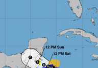
The threat of a new round of stormy tropical weather is rapidly diminishing for central Florida as Tropical Storm Sara is now forecast to move ashore over the Yucatan Peninsula of Mexico where it is expected to dissipate. The storm had been predicted for more than a week in forecast models, but the changing conditions in the atmosphere that originally pointed it to Florida have now pushed it farther west. After multiple rounds of hurricanes in what proved to be an active and...
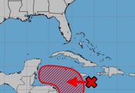
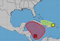
Weather-exhausted Floridians are casting a weary eye back at the tropics this week as yet another tropical cyclone is expected to threaten the state next week, even as Hurricane Rafael, briefly a Category 3 storm, fizzles in the Gulf. The National Hurricane Center in Miami has identified a new area of disturbed weather south of Cuba that is expected to drift to the west across the Caribbean as it slowly becomes better organized. Forecasters there are currently giving it an 80...
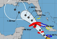
Tropical Storm Rafael, expected to soon reach hurricane strength as it moves toward Jamaica, Cuba, and the southeastern Gulf of Mexico, is expected to hold little threat for central Florida, but could bring welcome rains. The cyclone, which reached tropical storm strength on Monday, could undergo a period of rapid intensification due to its passage over the still superheated waters of the Caribbean. Once it enters the Gulf of Mexico region, however, hostile conditions and...
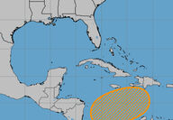
Ridge-area residents will find a changing weather pattern over the coming week as the tropics become active once again. The western Caribbean's "Central American Gyre" that has already spawned two destructive hurricanes is once again the source of potential trouble. The National Hurricane Center in Miami is tracking a few disturbances already, and models are suggesting that others may follow. A broad circulation, still devoid of significant storms, is being given an 80...
After suffering through the most destructive hurricane season on record, will Florida face yet another bout of severe tropical weather in November? That is the question being considered by forecasters as long-range models are suggesting that scenario. Several models monitored by Lake Wales News as well as meteorologists at the National Hurricane Center and elsewhere are predicting the formation of yet another cyclone to our south. If it reaches tropical storm force winds...

Two people who broke into a home on on Fast Trot Trail, allegedly to "escape" during Hurricane Milton, were arrested and charged with burglary and criminal mischief in additional to other charges. The Polk County Sheriff's Office arrested the two suspects on Thursday, October 10, for burglarizing the vacant home in the aftermath of the storm. Deputies responded to a 9:40 a.m., call about a residential burglary in progress and found the rear door pried open. The two suspects we...

The Florida Division of Emergency Management has announced the opening of Operation Blue Roof, which will provide and install a tarp on roofs damaged during the passage of Hurricane Milton. Operation Blue Roof is a program offered by FEMA through the U.S. Army Corps of Engineers to eligible homeowners and landlords. It provides a temporary covering of blue plastic sheeting to help reduce further damage to property until permanent repairs can be made. The blue plastic sheeting...

Nature is trying to make up and be nice after a few harrowing weeks of extreme events across central Florida. Autumn is arriving at last, much to the delight of Ridge-area residents fatigued from rounds of hurricane preparation, clean-up, and power outages. Forecasts for the coming week include the first solid wave of cool weather, building upon the welcome break in the heat that followed the passage of Hurricane Milton. Early-morning temperatures are expected to dip into the...

In a colorful and welcome respite from hurricane clean-up, area residents will have an opportunity to enjoy shopping for new flowering plants and garden items from among thousands on display at the annual Plant and Garden Festival this weekend. The free two-day event, October 19 and 20, is hosted by the GFWC Woman's Club of Lake Wales and will feature vendors and nurseries from across Florida who will offer their growing things. Decorative annuals, perennials, shrubs and trees...

In a heart-wrenching incident, a 10-year-old passenger was crushed to death by a 2,700-pound off-road vehicle after it rolled over during a turn on Thursday. The incident happened shortly after the passage of Hurricane Milton. The vehicle, a 2022 Polaris Ranger, was being driven by a 15-year-old. A group of other children were also aboard as passengers. All were ejected when the vehicle flipped. No driver's license is required to drive an off-road vehicle. They also lack many...

Friday dawned as another day without power for thousands of residents of southeast Polk after the area after Hurricane Milton raked the area with 100 mile-per-hour winds and heavy rainfall before dawn Thursday. Shattered or uprooted trees, some punching holes in roofs, along with damage to signs, sheds, utilities and fences were visible across the area. Flooded roads and intersections delayed responses to the disaster, a common scene as hurricanes increase in both frequency...
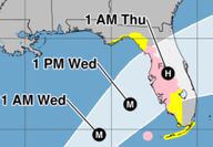
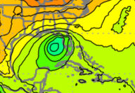
The latest update from the National Hurricane Center in Miami has raised the stakes for a direct strike upon southeast Polk County and the Lake Wales area. Residents are strongly urged to rush preparations to completion. The 11 a.m. NHC report said that with sustained winds of 155 MPH, Hurricane Milton is continuing to approach Florida. Continued intensification is expected, and Milton should be at Category 5 this afternoon with sustained winds of 160 MPH or more, accompanied...
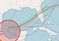
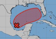
The latest computer model runs have placed Polk County directly in the crosshairs of a potential major hurricane. Residents may wish to begin preparation for a storm. The Nat According to the 11 a.m. statement from the National Hurricane Center in Miami, the area of disturbed weather in the western Gulf of Mexico is now a tropical depression, and will begin intensifying as it moves slowly northeastward over the next 24 to 36 hours before accelerating toward Florida. Arrival...
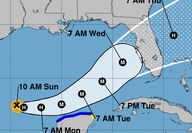
A slight south-eastward movement of Tropical Storm Milton could offer a small ray of hope for southeastern Polk County as the storm approaches the west coast of Florida later this week. The worst impacts of the storm are expected locally on Wednesday. The 11 a.m. statement from the National Hurricane Center in Miami noted that the center of the intensifying cyclone has been moving slowly to the east-southeast, a trend that has moved the needle on the multiple computer models...
As predicted here last week, a new tropical cyclone is becoming organized in the Gulf of Mexico and is expected to bring heavy rains to Florida and the Lake Wales Ridge this week. The storm is generally developing in line with the super-computer models closely followed by Lake Wales News. Those same models are now predicting the improving organization of the potential cyclone this weekend as it moves eastward toward the Florida peninsula from the western Gulf. The National...
As the nation takes account of the staggering loss of life and damage caused by Hurricane Helene, hurricane forecasters and Florida emergency managers are already casting a wary eye toward the Caribbean, where the active Central American Gyre (CAG) is in the process of generating another potential mega-storm. Florida's west coast took the worst of Helene, leaving the interior largely free of damage. Severe storm-surge that caused millions in damages to beach towns, while Polk...

Polk County and the Ridge will escape the worst effects of Hurricane Helene, but area residents should still be prepared for a blow, according to specific forecasts. Heavy rains and winds gusting to near hurricane force are also possible as the storm passes to the west. Helene, currently entering the southeastern Gulf of Mexico, is expected to charge north and northeastward as it rapidly intensifies to become a major hurricane, reaching Category 3 on the Saffir-Simpson scale,...
Florida residents are urged to be alert and prepared as Hurricane Helene is likely to form rapidly and bring the threats of high winds and flooding to Florida this week. National Hurricane Center forecasters are suggesting a 90 percent chance of a cyclone growing from an area of disturbed weather over the Caribbean by Tuesday. That system is then expected to move northward through the eastern Gulf of Mexico, where rapid intensification is possible. The NHC has been predicting...

UPDATE: New information is available here: https://www.lakewalesnews.net/story/2024/09/18/news/breaking-news-hurricane-helene-expected-to-move-northward-near-florida-this-week/4475.html After a surprisingly quiet several weeks in the midst of the hurricane season, it's time for Floridians to make certain that they are prepared for a storm as the tropics begin to heat up. Forecast models are developing a low over the Caribbean that could become a significant cyclone in the...