
Communication Builds Our Community
Communication Builds Our Community
Long-range Models Still Show No Threats
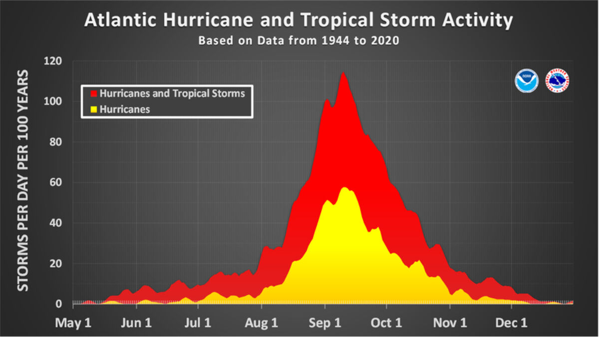
The fast-approaching peak of the hurricane season shows that most storms form in the period between August 20 and October 15. The peak is generally marked as falling on September 10, which is the anniversary of 1960's Hurricane Donna strike across Florida.
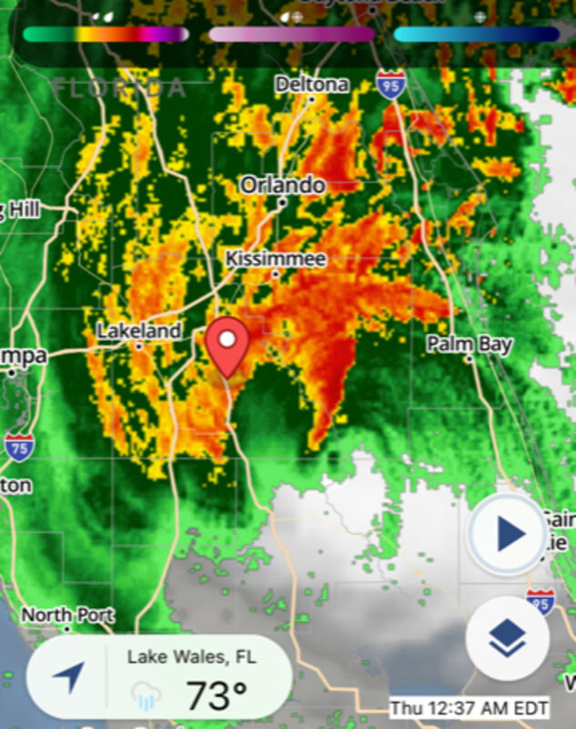
Last year's Hurricane Ian passed very near Frostproof, but wind shear had caused the storm to "lean" as the offset loops in the image show. That "lop-sided" structure left the strongest surface winds east of the eye, while the heaviest rains fell on the west side. Most areas along the Lake Wales Ridge received between one and two feet of rain.
As the 19th anniversary of the devasting impact of Hurricane Charley approaches on August 13, many Ridge area residents turn a wary eye on the tropics. Despite "super-heated" waters in most of the Atlantic basin the 2023 Hurricane season has, so far, remained a no-show. A global weather shift may be the cause.
A phenomenon called the Pacific Decadal Oscillation, or PDO, features alternating waves of colder or warmer waters in the eastern Pacific. It has huge influence on Florida's weather, generating "rivers" of winds and moisture in the upper atmosphere that can stimulate or destroy developing tropical systems.
Named because the cycles were measured to last a decade or longer, in recent years that fluctuation has changed. According to NASA's Jet Propulsion Laboratory, "a 'cool' phase occurred from 1947 to 1976 (29 years), and a 'warm' phase from 1977 to 1999 (22 years). However, more recently, the 'warm' and 'cold' phases have been much shorter."
This year the lingering effects of the four-year "La Nina" has shifted rapidly to the opposite "El Nino" pattern, which often generates strong upper-atmosphere winds that shear hurricanes apart by "unstacking" them. Yet there is a tradeoff, as past El Nino years have also produced very wet winters in Florida, along with violent outbreaks of tornadoes.
Standing in favor of potential strong hurricanes during the September heart of the season are water temperatures that stand at record levels. A buoy near the Florida Keys last month recorded a water temperature of 101.1° F, more suitable for a hot tub temperature than a habitat for fish and corals.
Across the entire Atlantic, Gulf and Caribbean, average water temperatures are as much as four degrees above normal. As steaming water releases energy to the atmosphere, it's a potent mix for strong hurricanes.
Florida has experienced an above-normal number of hurricanes in recent years, and more have been classified as "major" storms. In 2004, Lake Wales was in the cross-hairs of three different hurricanes as Charley, Francis and Jeanne impacted Florida and each of the eyes passed over the city in six weeks. That extremely-rare event followed 44 years without a storm since the 1960 strike by Hurricane Donna.
Since that fateful year the area has experienced the impacts of Hurricane Irma in 2017 and Hurricane Ian in 2022, which also created considerable damage across central Florida. All six of the storms that have struck the Lake Wales area originated as tropical waves from Africa.
During the early and late portions of the season, June and October/November, most storms are normally born from the remains of fronts stalled over the Gulf of Mexico or Caribbean. The African storm season started unusually early this year as two systems were spun up in June, only to meet the wind-shear effects that prevented them from approaching North America.


Reader Comments(0)