
Communication Builds Our Community
Communication Builds Our Community
Hurricane Expected to Become Category Three By Tonight
A radar image of Hurricane Idalia makes clear the close approach the storm will make to the west coast of Florida on its current track.
Precautions are advised for strong winds and heavy rains due to the approach of Hurricane Idalia, still expected to move near Florida's Gulf Coast overnight on Wednesday.
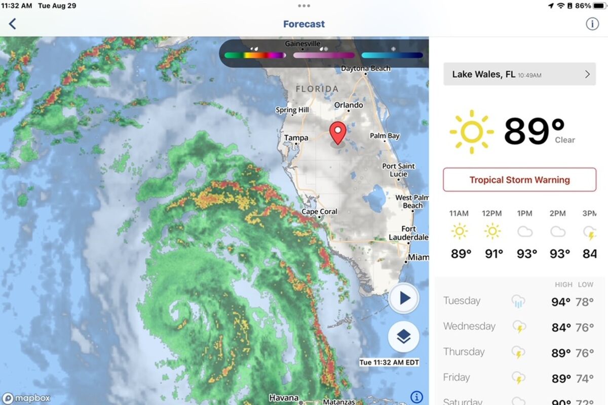
The 11:00 am, update from the National Hurricane Center in Miami indicates that the center of the storm is still on a generally northward track of five degrees, indicating a slight eastward movement. Any increased eastward adjustment in the course would raise the potential impacts of the storm in the east Polk County area.
Radar tracking and Hurricane hunter reports indicate that an eye is beginning to form as the intensity of the storm increases. The central barometric pressure of the storm has dropped to 976 millibars, or 29.82 inches of mercury, indicating a stronger convection. Winds have strengthened to 85 mph.
Along with the stronger winds come increased likelihood of Tropical Storm force winds over the Lake Wales area, now indicated as 50 to 60 percent chance. Models currently show no chance of Hurricane force winds locally, although Pinella County now falls into a 50 percent chance.
Idalia reached Hurricane intensity overnight, and is expected to undergo a period of rapid intensification today as it moves parallel to the west coast of Florida, assuring that it will make its closest pass to our area as a major Hurricane with winds exceeding 112 mph. .
As long as the storm continues to follow predictive models, the Lake Wales area should be spared a severe storm. Ironically, the same models that predicted the formation and approach of the storm two weeks ago, as reported in the Lake Wales News.net, are now showing a future track that turns the storm southward from the Carolinas, once again approaching Florida, but this time from the east. We will continue to monitor those models and bring you the latest information.
Polk County public schools have announced closings for both Wednesday and Thursday. Lake Wales Charter Schools will be closed on Wednesday, and evaluate conditions before determining a potential return to classes on Thursday. Widespread power outages would preclude that option, according to officials. Lake Wales News.net will publish changes to school schedules as they are announced.
Polk State College and its collegiate high schools will close at 5 p.m. on Tuesday, August 29, and remain closed through Wednesday, August 30.
Those wishing to access sandbags to protect against possible flooding in low-lying areas can pick up bags at the Lake Wales Fire Department. Sand to fill them is available at Lake Wailes Park. Other locations for sandbags are at Polk Road Maintenance units in Frostproof at 350 County Road 630A, phone (863) 635-7879, or in Dundee at 805 Dr. Martin Luther King St. SW, (863) 421-3367.
Heavy rainfall is forecast over the Lake Wales Ridge area and west central Florida in particular, but should not begin until late today or tonight. A dry summer has left area lakes with excess capacity, so the risk of serious flooding is quite low.
A dip in the jet stream is still forecast to push Idalia to the east beginning tonight or Wednesday morning, causing it to reach the coast north of Cedar Key. Three times in the last 19 years similar forecast tracks led to storms that shirted their tracks to the east ahead of forecast, causing direct strikes on the Lake Wales area.
Residents are encouraged to complete their preparations for the storm, enacting Hurricane plans. Maintaining supplies of water and canned or dried foods and emergency or solar lighting can provide essential comforts. Filling empty plastic containers to 90 percent full and placing them in empty space in freezers will help sustain frozen foods for longer periods of time in the event of power outages.
Lake Wales News.net will bring fresh updates at least every six hours as we continue to track developments. We use a variety of modelas and software to track conditions in the tropics and bring readers our locally-focused analysis of potential threats. The potential development of this system was predicted by our monitored models two weeks ago, as reported in our story of August 14.
Readers are again reminded to update their Hurricane plans.


Reader Comments(0)